User Tools
Sidebar
en:navigation
Book Creator
Add this page to your book
Add this page to your book
Book Creator
Remove this page from your book
Remove this page from your book
This is an old revision of the document!
Navigation methods/tools
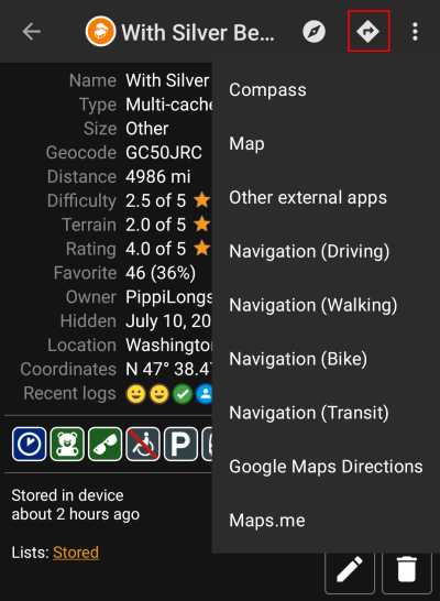
When invoking a navigation towards coordinates the following menu will be shown to select an appropriate navigation method/tool.
The following table provides an overview of the different methods/tools supported. Some items are only shown if the corresponding tool is installed. You can customize the items shown in this menu in the settings.
| Name | Description |
|---|---|
| Compass | Starts the c:geo built-in compass. |
| Radar | Starts apps supporting a radar functionality, such as GPS Status & Toolbox. A radar is similar to a compass but showing your position in the center and the target position in relation to this. |
| Map | Opens the c:geo map |
| Static Maps | This feature was removed. |
| Download Static Maps | This feature was removed. |
| Locus | Starts Locus to display the coordinates on the map. |
| Navigation (Driving) | Starting Google Maps turn-by-turn navigation using the preferences for a car route. |
| Navigation (Bike) | Starting Google Maps routing turn-by-turn navigation the preferences for a bike route. |
| Navigation (Walking) | Starting Google Maps routing turn-by-turn navigation the preferences for a walk route. |
| Navigation (Transit) | Starting Google Maps routing turn-by-turn navigation the preferences for a route with transit providers. |
| Street View | Start Google Street View on the coordinates. |
| OruxMaps (Online) | Start OruxMaps using online turn-by-turn navigation. |
| OruxMaps (Offline | Start OruxMaps using offline turn-by-turn navigation. |
| Sygic (Walking) | Start Sygic turn-by-turn navigation using preferences for a walk route. |
| Sygic (Driving) | Start Sygic turn-by-turn navigation using preferences for a car route. |
| OsmAnd | Start OSMAnd offline turn-by-turn navigation. |
| Google Maps Directions | Opens Google Maps to show a list of driving directions from your current position to the coordinates. |
| WhereYouGo | This item is only available for Wherigo caches and will open WhereYouGo to download the needed cartridge and further navigate through the stages of the cache. |
| Pebble | Start compass on your pebble device using the Pebble Navigation app. |
| Maps.me | Start offline turn-by-turn navigation using the maps.me app. |
| Other external apps | This invokes other apps not explicitly supported by c:geo. Using this option will usually open an app selection dialog on your device presenting all apps capable of digesting links containing coordinates. |
This website uses cookies. These cookies are used to store your login status (if enabled) and your personal preferences (such as language selection). There are no tracking cookies or other scripts involved. By using the website, you agree with storing cookies on your computer. If you do not agree please leave the website or delete the cookies anytime you want as they are not essential to use this website.More information about cookies
en/navigation.1556036201.txt.gz · Last modified: by lineflyer
Except where otherwise noted, content on this wiki is licensed under the following license: CC Attribution-Noncommercial-Share Alike 4.0 International


