Diese Übersetzung ist älter als das Original und ist eventuell veraltet. Änderungen zeigen.
Übersetzungen dieser Seite?:
Dies ist eine alte Version des Dokuments!
 Diese Seite wurde noch nicht vollständig übersetzt. Bitte helfen Sie bei der Übersetzung.
(diesen Absatz entfernen, wenn die Übersetzung abgeschlossen wurde)
Während die Live-Karte angezeigt wird, wird der Bildschirm deines Gerätes nicht mehr automatisch abgeschaltet. Du musst die Karte verlassen, damit der Bildschirm wieder automatisch (zeitgesteuert) zum Energiesparen abgeschaltet wird. Natürlich ist es weiterhin möglich den Bildschirm manuell abzuschalten.
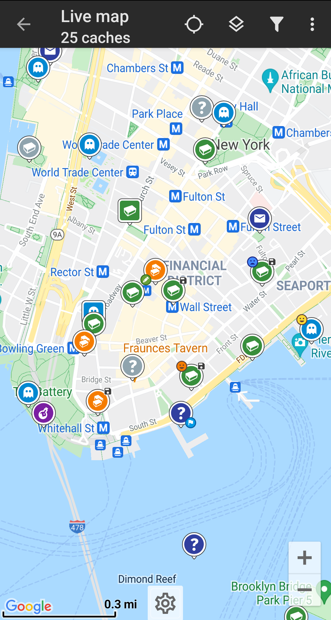
Die Symbole in der Titelzeile und der Inhalt hinter dem Überlauf-Symbol werden dynamisch basierend auf deiner Geräteauflösung und Bildschirmausrichtung verteilt. Daher ist es möglich, dass auf deinem Gerät mehr oder weniger Einträge entweder als Symbol angezeigt oder hinter dem Menü-Symbol versteckt sind.
Wenn ein Menüeintrag als Symbol angezeigt wird, kannst du lange auf das Symbol klicken um seine Funktion angezeigt zu bekommen.
| Symbol | Funktion | Beschreibung |
|---|---|---|
 | Karteninformation | Zeigt den aktuellen Kartenstatus: Live-Karte wenn die Karte live ist, Karte wenn die Aktualisierung abgeschaltet wurde oder den Namen einer Liste, welche auf der Karte angezeigt wird.Darüber hinaus wird die Anzahl der auf der Karte sichtbaren Caches angezeigt. |
| Fortschrittsanzeige | Eine Fortschrittsanzeige, die angezeigt wird während die Live-Karte Daten vom Geocacing-Server und/oder von deinen Listen abruft. Sie verschwindet, wenn die Live-Karte fertig geladen ist. | |
| Position zentrieren | Diese Schaltfläche kann genutzt werden um die Karte auf deine aktuelle Position zu zentrieren. Wenn die Karte auf deine Position zentriert ist, wird ein gefülltes Symbol angezeigt. |
|
| Kartenauswahl | Benutze diese Schaltfläche um die aktive Kartenquelle auswzuwählen. | |
| Überlauf-Menü | Ein Klick öffnet das Menü der Funktionen, die nicht mehr als Symbol in die Titelzeile auf deinem Gerät passen und daher als Liste angezeigt werden. Die Funktionen in dieser Liste werden auch alle in dieser Tabelle beschrieben. | |
| Aktualisierung einschalten/ausschalten | Diese Funktion schaltet die Aktualisierung der Live-Karte an/aus. | |
| Alle speichern | Speichert alle auf der Karte angezeigten Caches in deine Cache-Liste. Bereits gespeicherte Caches werden dabei aktualisiert. | |
| Neue speichern | Speichert alle auf der Karte angezeigten Caches mit Ausnahme der bereits gespeocherten Caches in deine Cache-Liste. | |
| Karteneinstellungen | Dies öffnet ein Menü mit diversen Optionen um die Kartendarstellung anzupassen (e.g. Ausblenden von gefundenen Caches, Kreise anzeigen, usw). | |
| Routing | Dieser Funktion erlaubt es zwischen verschiedenen Routing-Voreinstellungen zu wechseln (z.B. gerade Linie, Autoroute, Fahrradroute). | |
| Strategie | Mit dieser Funktion änderst du die Strategie, mit der c:geo Daten auf die Live-Karte lädt. | |
| Als Liste anzeigen | Dies zeigt alle auf der Karte angezeigten Caches als Liste. |
Die Karte nutzt deine gewählten kartentyp und zeigt eine Live-Ansicht aller verfügbaren Caches an der angezeigten Position.
Die Live-Karte zeigt dir immer eine Kombination von sowohl live geladenen Caches aller deiner aktivierten Geocaching-Dienste als auch deiner gespeicherten Caches aus deinen Cachelisten.
Die folgende Tabelle beschreibt die verschiedenen Markierungen, die auf der Live-Karte genutzt werden.
Diese Tabelle beschreibt nur die verschiedenen Symboltypen, nicht die verschiedenen Typen von Geocaches. Unter den folgenden Links bekommst du Informationen über die Geocache-Symbole in c:geo und die Geocache-Markierungen in c:geo, wie sie überall in der App verwendet werden.
| Symbol | beschreibung |
|---|---|
| Dieser Pfeil repräsentiert deine aktuelle Position und Ausrichtung auf der Karte. | |
| Position eines Caches von geocaching.com. Der Pfeil zeigt auf die Koordinaten dieses Caches auf der Karte. Der Symbolrahmen enthält den entsprechenden Cachetyp. | |
| Position eines Caches von geocaching.com., bei dem die Positionierung auf der Karte durch die gewählte Ladestrategie nicht ganz präzise sein könnte. Der Symbolrahmen enthält den entsprechenden Cachetyp, den c:geo erkannt hat, aber diese Information könnte falsch sein. | |
| Position eines deaktivierten oder archivierten Caches von geocaching.com. Der Pfeil zeigt auf die Koordinaten dieses Caches auf der Karte. Der Symbolrahmen enthält den entsprechenden Cachetyp. | |
| Position eines Caches von einer Opencaching-Plattform. Der Pfeil zeigt auf die Koordinaten dieses Caches auf der Karte. Der Symbolrahmen enthält den entsprechenden Cachetyp. | |
| Position eines deaktivierten oder archivierten Caches von einer Opencaching-Plattform. Der Pfeil zeigt auf die Koordinaten dieses Caches auf der Karte. Der Symbolrahmen enthält den entsprechenden Cachetyp. | |
| Position eines Caches von einer anderen Quelle als geocaching.com oder Opencaching (z.B. extremcaching.com). Der Pfeil zeigt auf die Koordinaten dieses Caches auf der Karte. Der Symbolrahmen enthält den entsprechenden Cachetyp. |
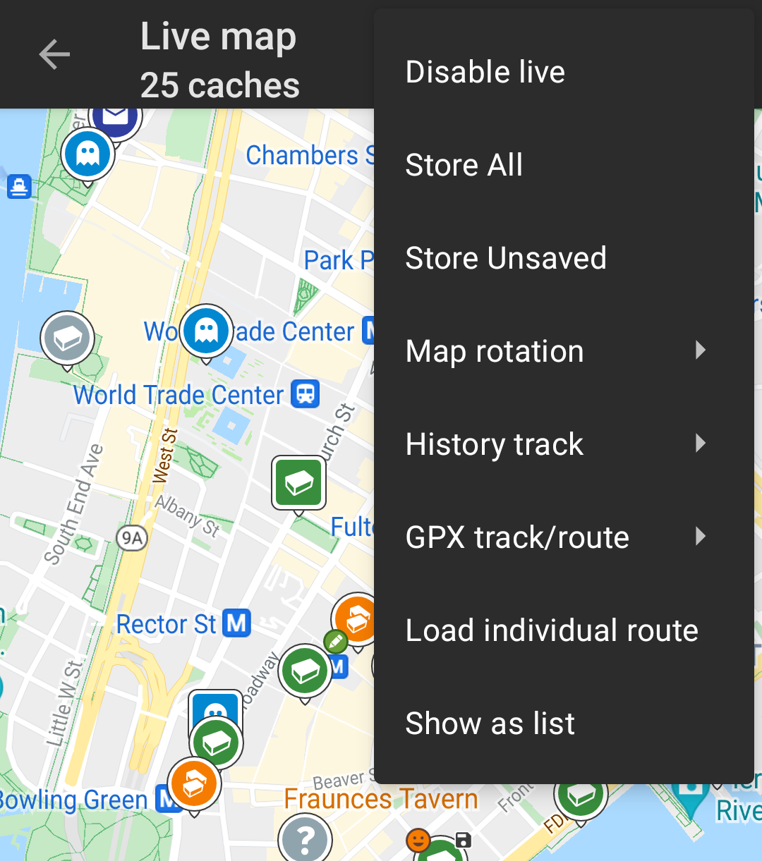
If you click on a cache icon on the live map the following popup windows will be shown above the map, providing additional information for the selected cache:
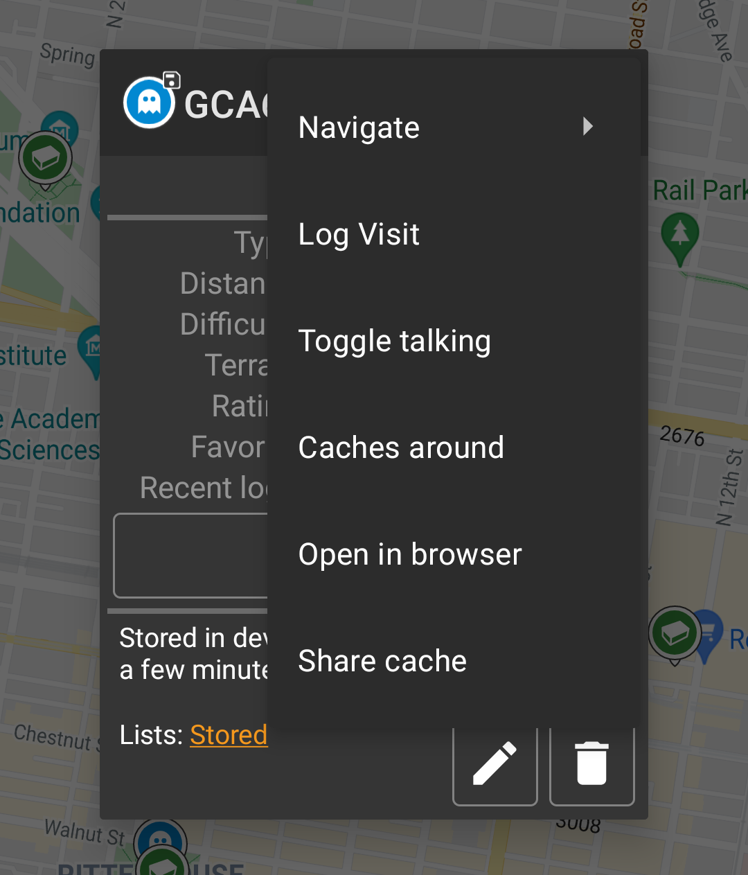
This section of the map popup provides several menu options concerning the selected cache.
| Icon/Option | Description |
|---|---|
 | Showing the Cache type icon and the title of the selected cache. |
| A short click on this icon will start your default navigation tool to navigate to the selected cache. A long press will start your secondary navigation tool. |
|
This options turns on/off the direction line/routing between your position and the position of the selected cache. This option is currently only available on the OSM:Mapnik online map and offline maps. This option is currently only available on the OSM:Mapnik online map and offline maps. |
|
| This option opens a menu list with additional options also described in this table. | |
| Compass | This opens the compass for this cache. |
| Navigate | This opens the list of all available navigation tools to start one of them for this cache. |
| Log Visit | This opens the logging window to log the selected cache. |
| Caches around | This option starts a nearby search around the coordinates of the selected cache and will display the results. |
| Open in browser | This option opens the cache listing on the geocaching web page using your internet browser. |
| Remove | This option will delete the cache from your stored lists. GITHUB → KANN WEG |
| Share Cache | Will share a link to the cache using the built-in Android share options. |
The middle section of the map popup window shows helpful information about the selected cache. Some of the information might not be shown depending on the loading status of the selected cache (e.g. due to the [livemap#strategy| loading strategy]].

| Heading | Description |
|---|---|
| Type | Type of the selected cache. |
| Geo code | Geo code of the selected cache. |
| Distance | Distance to the coordinates of the selected cache from your current position. |
| Difficulty | Difficulty rating of the selected cache shown as decimal value as well as graphical. |
| Terrain | Terrain rating of the selected cache shown as decimal value as well as graphical. |
| Rating | Shows the quality rating of this cache from GCVote if this service is enabled in the c:geo settings as decimal value as well as graphical. The value shown in parenthesis is the number of votes given for this cache. |
| Favorite | The amount of favorite points (geocaching.com) or recommendations (Opencaching platforms) the selected cache has been awarded. |
| More details | This button will take you to the cache detail page of the selected cache providing the full information for this geocache. |
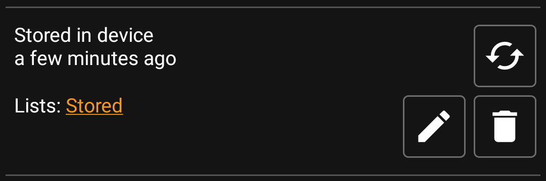
This section of the map popup provides several options to manage the storage state of the selected cache.
| Icon/Option | Description |
|---|---|
 | This field provides information if the selected cache is stored on your cache lists and for how long the cache is stored (i.e. gives you an indication of how up-to-date the shown details are). |
| Clicking this button will refresh the cache information by updating it from the geocaching server. | |
 | In case the selected cache is already stored in your cache lists this field shows you the list(s) it is stored in. |
| This button is only shown if the selected cache is not yet stored in your cache lists and will store it. A long press on this icon will store the cache to the last used list, instead of asking for the list. |
|
| If the selected cache is already stored in your cache lists this icon is shown and allows you to modify the list or add the cache to another list. | |
| If the selected cache is already stored in your cache lists this icon is shown and allows you to delete the cache from your lists. |
After selecting the menu function Map settings the following option screen will be shown:

| Option | Description |
|---|---|
| Hide own/found caches | If activated your owned and found caches are hidden on the map. This is the same option as also available in c:geo settings and changing it here will change it also permanently in your settings. Please note, that some technical limitation apply for hiding your owned and found caches as explained on the settings page |
| Hide disabled caches | If activated disabled caches are hidden on the map. This is the same option as also available in c:geo settings and changing it here will change it also permanently in your settings. Please note, that some technical limitation apply for hiding hidden caches as explained on the settings page |
| Show direction | This will enable/disable the direction line/routing shown between your position and a selected cache. |
| Show circles | If activated c:geo will show circles with a distance of 1/4 mile (161 meters) around all physical waypoints (i.e. traditional caches, physical stages of a cache, mystery caches with corrected coordinates). This is the minimum distance placed caches need to have on geocaching.com and these circle might be helpful when you are planning to hide a new cache and are looking for a position. |
| Show trail | With this option you can activate a trail showing your position history (your movement) on the map. This is the same option as also available in c:geo settings and changing it here will change it also permanently in your settings. |
After selecting the menu function Routing the following option screen will be shown:
This setting is will only be shown if a supported routing app is installed and available.

| Option | Description |
|---|---|
| Straight line | This will show a direct line (air distance) between your position and the selected cache. |
| Walk | This will set the routing app to draw a line following turn-by-turn navigation for pedestrians. |
| Bicycle | This will set the routing app to draw a line following turn-by-turn navigation for bikers. |
| Car | This will set the routing app to draw a line following turn-by-turn navigation for cars. |
After selecting the menu function Strategy the following option screen will be shown:

These options define the mechanism the live map uses to load cache data from geocaching.com. As loading live map data from geocaching.com is quite time intensive, you can choose faster strategies.
Other geocaching services will always use the Detailed strategy as for those the live map loading is much faster in general.
| Option | Description |
|---|---|
| Fast | Load approximated cache coordinates and tries to identify the cache type. |
| Detailed | Same as fast but load details for nearest 20 caches around your position. |
| Speed dependant | Automatic switch from Detailed to Fast above 30km/h. |
