Deze vertaling is ouder dan de originele pagina en kan verouderd zijn. Kijk wat er is veranderd.
Vertaling van deze pagina?:
Dit is een oude revisie van het document!
 Deze pagina is nog niet volledig vertaald. Help alsjeblieft de vertaling compleet te maken.
(verwijder deze paragraaf als de vertaling is voltooid)
Het belangrijkste doel van c: geo is om online toegang te hebben tot je geocachingplatform. C: geo biedt echter ook offline functionaliteit om te gebruiken zonder enige netwerkverbinding (bijvoorbeeld tijdens caching in het buitenland of buiten het bereik van mobiel netwerk).
Om c: geo volledig offline te gebruiken, moet je een aantal dingen voorbereiden, afhankelijk van je behoeften:
Deze pagina beschrijft deze off-line gebruiksscenario's.
Als je gegevensoverdracht wilt voorkomen, moet je de internetverbinding op je apparaat in het algemeen toch uitschakelen, omdat c: geo altijd zal proberen in te loggen zodra je ermee bent begonnen. Op de meeste apparaten wordt de internetverbinding automatisch verbroken tijdens roaming-omstandigheden of wanneer mobiele data is uitgeschakeld.
GPX-bestanden bevatten informatie over caches en hun waypoints. Je kunt GPX-bestanden ophalen uit verschillende bronnen, bijvoorbeeld als premium lid van geocaching.com kun je lijsten van pocketquery's exporteren als GPX-bestanden.
C: geo ondersteunt expliciet GPX-bestanden van geocaching.com en GPX-bestandsextensies van opencaching-sites, maar als je GPX-bestand van een andere bron komt maar dezelfde syntaxis gebruikt, zal het waarschijnlijk ook werken.
Om een GPX-bestand te importeren, heb je twee opties:
* Gebruik een bestandsbrowser op je apparaat, klik op het GPX-bestand dat op je apparaat is opgeslagen en selecteer c: geo als doel-app.
Dit toont een selectievenster, waarin je de doel lijst moet selecteren om de caches uit het GPX-bestand te importeren.
* Open een lijst van opgeslagen caches of maak een nieuwe lijst en selecteer Menu → Importeren → Importeer GPX . Dit zal de geconfigureerde map van GPX-bestanden gebruiken en biedt je de mogelijkheid om daar een bestand te kiezen.
Nadat het importproces is voltooid, bevat de geselecteerde lijst nu de geïmporteerde caches.
Houd er rekening mee dat sommige informatie over de cache niet is opgenomen in GPX-bestanden. In het geval dat je enkele van de volgende informatie nodig hebt, moet je deze handmatig toevoegen door bijv. de cache online te vernieuwen:
| Informatie | Omschrijving |
|---|---|
| Attributen | Om ervoor te zorgen dat de GPX-bestanden van geocaching.com de cache eigenschappen bevat, moet je ervoor kiezen om GPX-versie 1.0.1 op de website te gebruiken. |
| GCVote-beoordeling | Omdat GCVote een externe service is, is de informatie niet opgenomen in GPX-bestanden |
| Lijst met afbeeldingen | Het GPX-bestand bevat de koppelingen naar elke afbeelding die de eigenaar gebruikt in zijn cachebeschrijving, maar bevat de afbeelding zelf niet. Je moet de cache online openen of de cache vernieuwen om de afbeeldingen te laden |
| Log afbeeldingen | Het GPX-bestand bevat de links naar afbeeldingen van gebruikers die aan hun logboekvermeldingen zijn gekoppeld, maar bevat de afbeelding zelf niet. Je moet de cache online openen of de cache vernieuwen om de afbeeldingen te laden |
| Favorieten | Om ervoor te zorgen dat de GPX-bestanden van geocaching.com de favorieten van een cache bevatten, moet je ervoor kiezen om GPX-versie 1.0.1 op de website te gebruiken. |
| Statische kaarten | Als statische kaarten zijn een optie van c: geo en staan niet in GPX-bestanden, maar worden (optioneel) als laatste stap toegevoegd tijdens het importeren van een GPX-bestand. |
You have two possibilities of composing offline logs in c:geo:
Save offline function in the logging screen menu.Offline Log function in the settings which completely works offline.
While the first option is not different from online usage, the second option will replace the Log Visit menu by a One click offline log menu in all places. As soon as the function is activated, c:geo will not post logs online by default but only store the found status offline.
When using this menu function the following context menu will be shown:
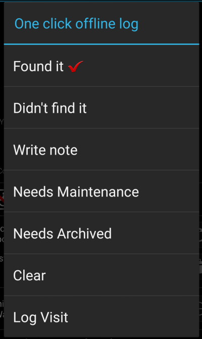
Just click on the desired log type and your offline log will be saved accordingly. The Clear option is only available if you already have an offline log stored for this cache. In this case the log type already stored is marked with a red tick in this menu.
You can also select Log Visit to open the normal logging screen to compose a complete log and store it.
Fieldnotes (a.k.a Drafts) are supported by geocaching.com and some opencaching sites and allow an offline logging of cache finds and batch uploading them to the website at a later point of time.
c:geo is supporting fieldnote export and also an automatic upload to the website (for geocaching.com).
The offline logged caches are marked by an orange line in your lists and with a red smiley on the map. To export the logs you have to open the relevant list of saved caches or the history and select Menu → Export → Field notes
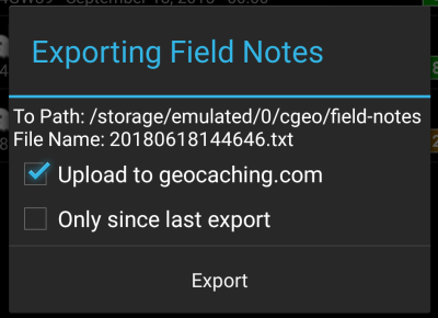
Fieldnote exports will be stored by c:geo in the directory /cgeo/field-notes in your internal storage with a date/time stamp used as filename as shown in the export dialog.
You can now either only export the fieldnote file to your device or additionally upload them to the geocaching website by enabling Upload to geocaching.com.
The option Only since last export will check the last upload date on geocaching.com and only export those field notes which are composed after this date.
After you exported your fieldnotes to the geocaching website, the website will show that you have pending fieldnotes on this page and you can compose your logs in your browser. Please be aware that it might take a minute after the upload until the website shows the pending fieldnotes.
This function can be activated in the settings for the cache coordinates and/or for its waypoints and will download Google maps images of the area around each saved cache both as street map and satellite view (a total of 5 images). It is a helpful feature if you plan to go caching without internet access (and maybe even without an offline map).
Also a basic street map will be shown at the bottom of the cache details page, the remaining maps are accessible by selecting Static Maps in the cache Navigation menu.
Please note, that there is a limit by Google of 1000 static maps per 24h per user(IP). Having a rather huge list of stored caches or even only some caches with many waypoints, you may easily reach this limit (as 5 images per cache and each cache waypoint are loaded). In this case some static maps might be missing.
The following shows an example of static maps for a cache. You can click the images to see a larger version:
| Description | Map |
|---|---|
| High zoom satellite view | 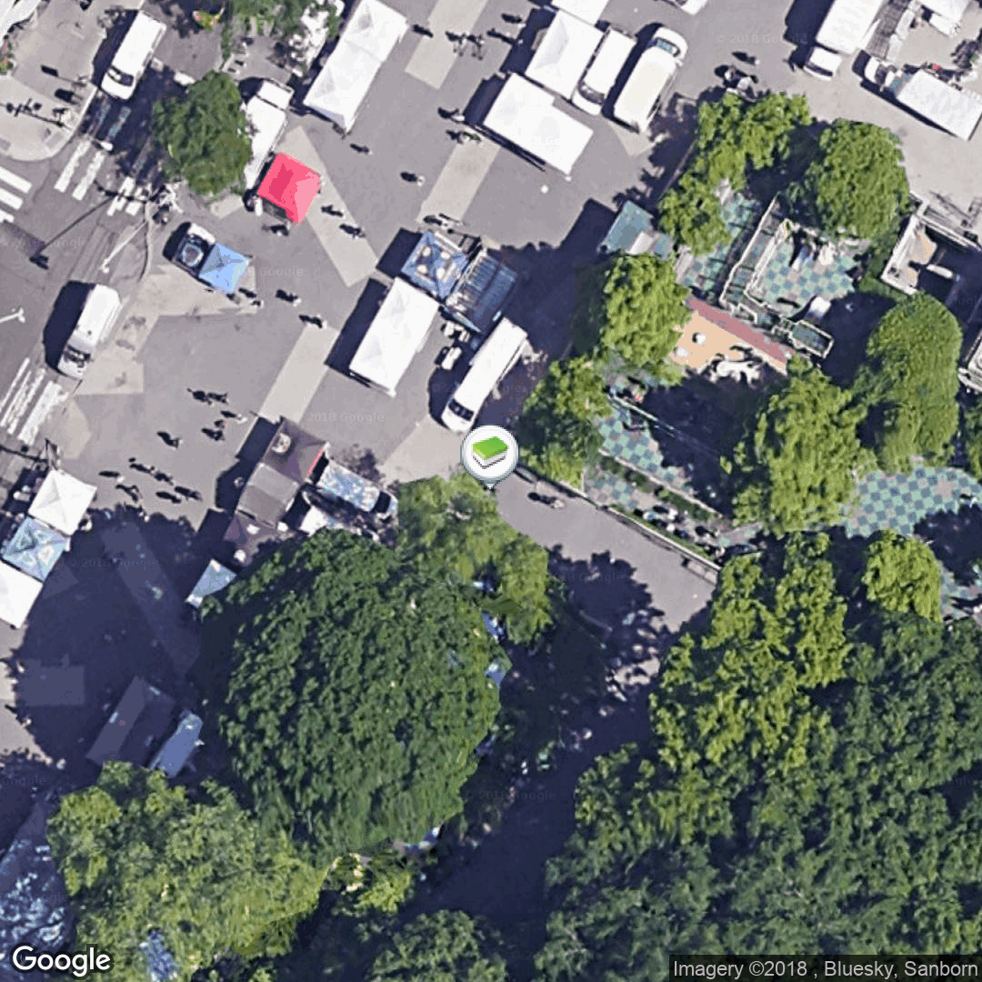 |
| Low zoom satellite view | 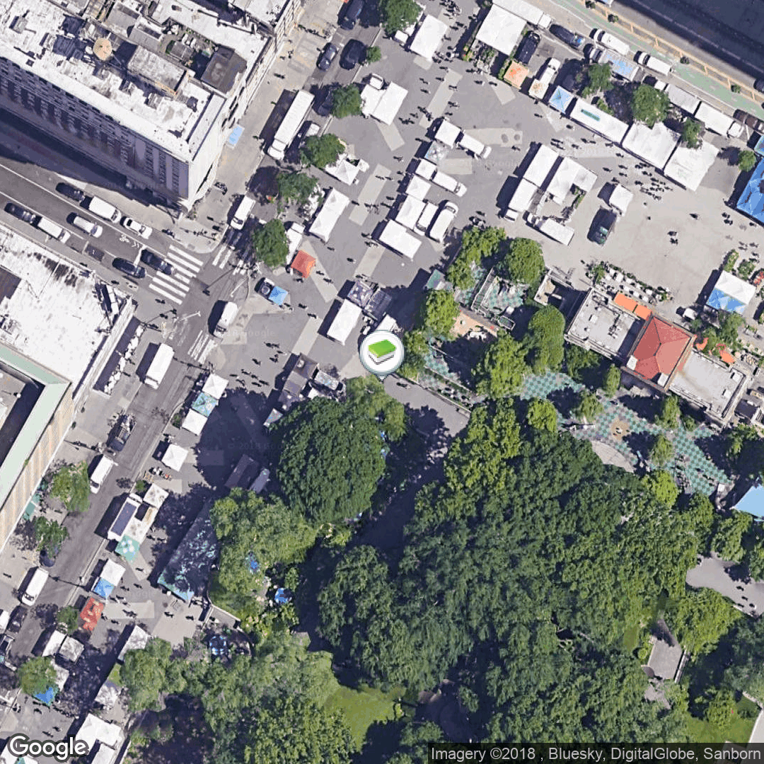 |
| High zoom street map view |  |
| Medium zoom street map view | 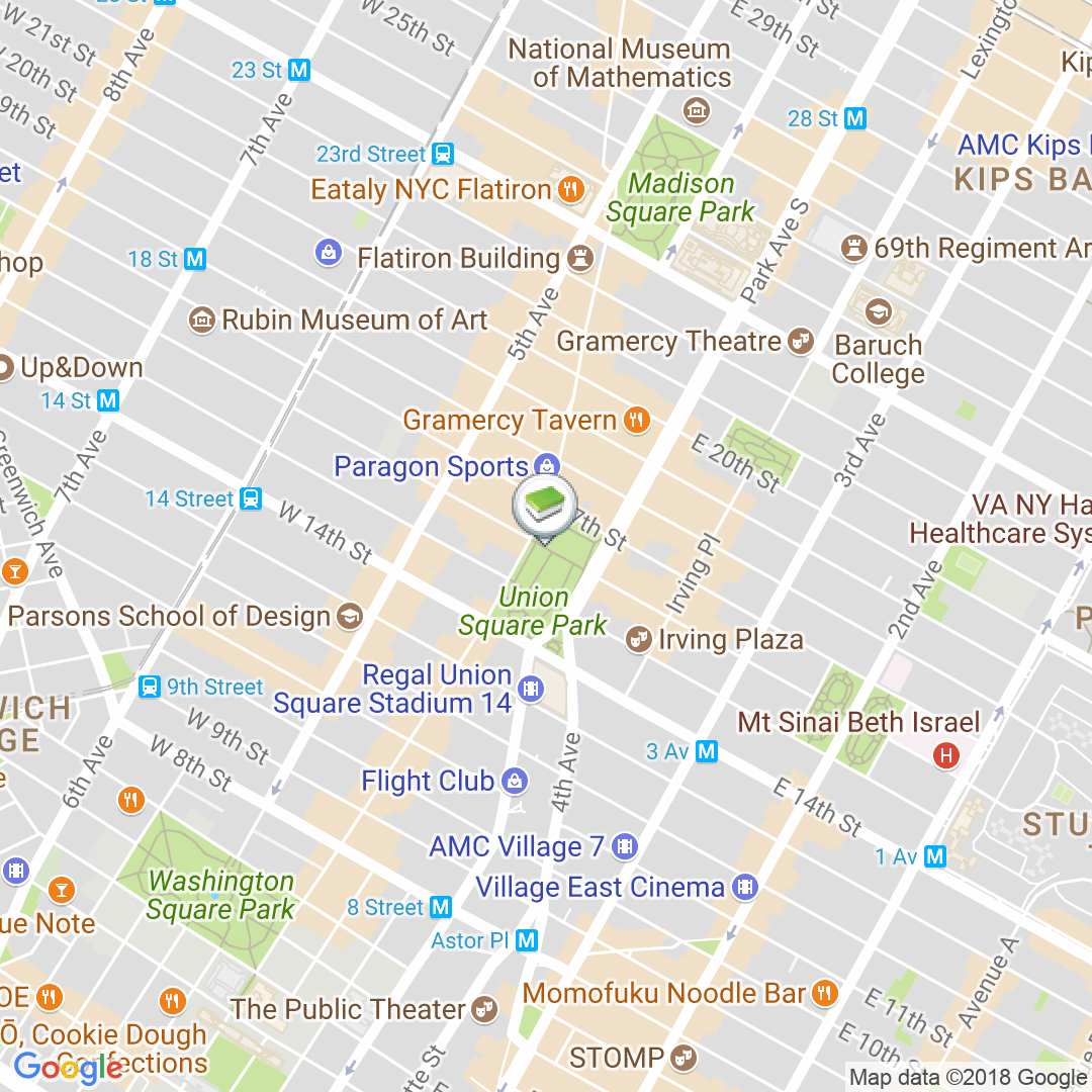 |
| Low zoom street view |  |
c:geo supports openstreetmap based offline map files using the mapsforge format.
Such files can be downloaded for your area/country from various sources, e.g. Mapsforge Download Server or OpenAndroMaps. With some effort you can also manually create your own openstreetmap based map.
Once you downloaded an offline map file, you have to store it to the directory on your device as defined in the settings. If the file is a valid mapsforge offline map, it will afterwards be shown in the map source selection on the live map or you can preselect the map file to be used in the settings.
