Deze vertaling is ouder dan de originele pagina en kan verouderd zijn. Kijk wat er is veranderd.
Vertaling van deze pagina?:
Dit is een oude revisie van het document!
 Deze pagina is nog niet volledig vertaald. Help alsjeblieft de vertaling compleet te maken.
(verwijder deze paragraaf als de vertaling is voltooid)

The coordinate input dialog is opened if you click on the coordinate field while editing a waypoint or for entering coordinates in the search or Go to menus.
The ![]() button will close the dialog without changes, the
button will close the dialog without changes, the ![]() will close the dialog and save the changes.
will close the dialog and save the changes.
Be sure to save the changes especially when using the waypoint calculator as no valid coordinates might be shown, but you still want to save the recent changes you made in the calculator.

By clicking on this field you can select between the different supported coordinate formats or selecting Plain to manually input the desired format. The coordinate input fields will change their layout depending on your selection here.
If you already entered coordinates these will be converted into the selected format.
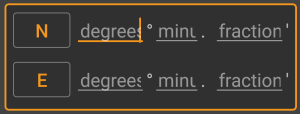
Use these fields to enter the coordinates. By clicking on N/W you can change to S/E as needed.
The layout of these input field depends on the coordinate format you selected above.
Below the coordinate input fields you will find several buttons allowing to insert coordinates from different sources. All or a subset of these buttons might be shown depending on where you use the coordinate input dialog and other conditions.
| Button | Description |
|---|---|
| My coordinates | Will insert your current position into the coordinate fields. |
| Cache coordinates | Will insert the cache listing coordinates into the coordinate fields. |
| Calculate coordinates | Will use the coordinates already entered above (optionally) and open the waypoint calculator. |
| From clipboard | This button is only shown if your clipboard contains valid coordinates and will paste them into the coordinate fields. |
| Clear coordinates | Empties the coordinate fields. |
c:geo offers a calculator for waypoints, which allows to make use of variables and formulas to calculate coordinates based on the result.
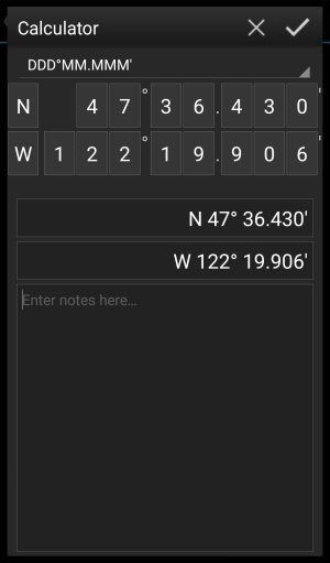
Once you clicked on Calculate Coordinates in the coordinate input dialog this screen will be shown.
The ![]() button will close the dialog without changes, the
button will close the dialog without changes, the ![]() will close the dialog, save the changes and return to the waypoint editor.
will close the dialog, save the changes and return to the waypoint editor.
You can use the calculator also for preparing your field trip by entering the needed variables and formulas but not yet entering values for your variables.
This will of course not yet provide a valid result, but you can still save the current state at any time by saving your changes in the calculator and afterwards saving the waypoint state.
Clicking on the first field will open a drop down menu allowing to change between different coordinate formats as explained here. All further functions are explained below.
For easier understanding we will use an example of how the calculator can be used.
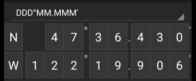
By default this section will show the cache coordinates as a starting point for assigning your variables.
By short clicking on each digit you can cycle between the following functions for this specific digit:
Furthermore you can long click each digit to manually enter a number or variable.
The result could look like this example:
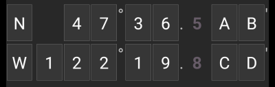
For the main variables you always have to use CAPITAL letters (A-Z), whereas for the sub variables (described further down) you always have to use lower case letters (a-z)!
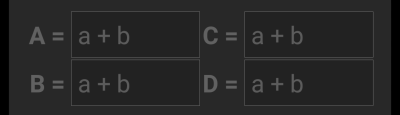
The section below the coordinate field will show fields for all the main variables you assigned in the coordinate field. In our example it will look like this as we assigned four main variables (A,B,C,D):
You can now use these fields to assign a formula using sub variables (lower case a-z) to calculate the result for the main variables.
The following operators are supported in these formulas:
| Operator | Function | Example |
|---|---|---|
| + | Addition | a+b |
| - | Subtraction | a-b |
| * | Multiplication | a*b |
| / | Division | a/b |
| ^ | Potentiate | a^b |
| % | Modulo | a%10 |
| ( ) | Parenthesis | (a+b)*c |
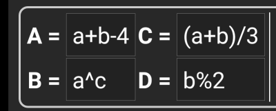
In our example, we use the following formulas for the main variables (as e.g. provided by the cache owner in the cache description) to continue:
For the sub variables you always have to use lower case letters (a-z), whereas for the main variables (described further above) you always have to use CAPITAL letters (A-Z)!
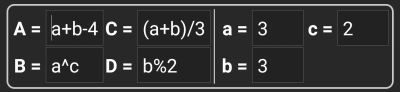
After assigning formulas to the main variables, an input field will be added automatically for each sub variable (lower case a-z) used in these formulas.
These input fields can now be used to enter numeric values, which will then be used for automatic calculation of the result coordinates using the formulas provided. You can close and save the calculator state at any time now and return to the calculator to enter the next sub variable value as soon as you found it while doing your cache.
Depending on the amount of main and sub variables you have to swipe the variable section to reach all input fields.
You might also rotate your device into landscape mode to have all variables visible on your display.
In our example we did now find the values for a,b and c and entered them accordingly:
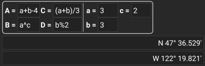
While you enter the formulas for the main variables and the values for the sub variables the result will be shown - on the fly in the result section.
Digits not yet valid will be replaced by * and greyed out. Once the result produces valid coordinates the result field will be shown with all white characters.
In our example a valid result is shown:
De laatste sectie in de rekenmachine kan worden gebruikt om notities in te voeren of te plakken, wat handig kan zijn voor bijv. het kopiëren van delen van de cache-beschrijving met de benodigde berekeningen om de cache te vinden.
De inhoud van de reken notities wordt gesynchroniseerd met de notitie van het waypoint dat is gebruikt om te berekenen.
Het invoeren van coördinaten of coördinaatformules in platte -modus werkt compleet anders dan de vaste formaten. In plaats van een klikbaar veld voor elk cijfer, zijn er twee vrije tekstvelden om het breedte- en lengtegraadgedeelte van een coördinaat in te voeren. Een enkel cijfer of een groep cijfers kan worden vervangen door een formule omringd met haakjes. De variabelen die in de formules worden gebruikt, moeten uit enkele HOOFDLETTERS bestaan.
Cache-lijsten bieden vaak hun waypoint-coördinaten al in dit verwachte formaat. Daarom is de gewone modus het meest geschikt wanneer coördinaten moeten worden overgenomen “zoals ze zijn” uit de cache.
De gewone modus werkt het beste met coördinaten in MinDeg format DDD° MM.MMM'.
Als je de modus Plat wilt openen, wijzig je het 'Coördinatenformaat' in Plat.
Neem het voorbeeld in de bovenstaande schermafbeelding en kopieer de breedtegraad (N/Z) -gedeelte van de coördinaat naar het eerste invoerveld en het lengtegraad gedeelte (O/W) naar het tweede. Als de coördinaat formules met variabelen bevat, verschijnen de overeenkomstige variabele invoervelden hieronder.
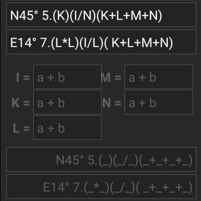
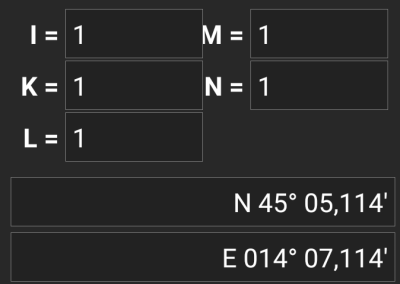
De formules van de schermafbeelding produceren invoervelden voor I, K, L, M en N. Je kunt de variabele velden met waarden op dezelfde manier vullen als met de vaste formaten die in de vorige secties zijn beschreven.
Zodra de invoer voor alle variabele velden is voltooid, wordt de resultaatvoorspelling meestal wit en wordt het berekende coördinaat weergegeven.
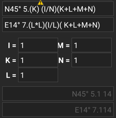
In sommige gevallen blijft het resultaatveld grijs omdat de coördinatenparser de initiële coördinaatinvoer niet correct kon interpreteren. In de onderstaande schermafbeelding is er een misplaatste SPATIE tussen twee cijfers van dezelfde groep die de coördinaten-parser verwart.
Typische problemen met coördinaten gekopieerd van lijsten zijn:
N45° 5.(K) (I/N)(K+L+M+N)N45 ° 5.(K)(I/N)(K+L+M+N)N45° 5 .(K)(I/N)(K+L+M+N)N45° 5. (K)(I/N)(K+L+M+N) - ) wordt geaccepteerd. x of een punt ( · ) genomen als vermenigvuldigingsteken in plaats van een asterisk ( * ): ) genomen als deelteken in plaats van een schuine streep ( / )N45° 5.[[X+Y]*10]Net als bij de andere formaten hierboven kan de rekenstatus op elk moment worden opgeslagen.
