This translation is older than the original page and might be outdated. See what has changed.
Translations of this page?:
Tämä on vanha versio dokumentista!
 This page is not fully translated, yet. Please help completing the translation.
(remove this paragraph once the translation is finished)
c:geon pääkäyttötarkoituksena on, että geokätköily tapahtuu online-tilassa. Kuitenkin c:geo tarjoaa myös offline-toimivuuden sen käyttämiseksi ilman internetyhteyttä (esimerkiksi ulkomailla kätköillessä tai matkapuhelinverkkojen ulkopuolella).
Jotta voit käyttää c:geota kokonaan offline-tilassa, sinun tulee valmistella joitakin asioita, tarpeidesi mukaan:
Tämä sivu selostaa nämä offline-käyttöskenaariot.
Jos haluat, ettei ohjelma käytä ollenkaan dataa, sinun tulisi kytkeä puhelimen asetuksista internetyhteys kokonaan pois päältä, koska c:geo aina yrittää kirjautua, kun olet käynnistänyt ohjelman. Suurin osa laitteista kytkee internetyhteyden pois päältä roaming-tilassa tai jos puhelimen verkkoyhteys on kytketty pois päältä.
GPX-tiedostot sisältävät tietoja kätköistä ja niiden reittipisteistä. Voit muodostaa ja ladata GPX-tiedostoja useista lähteistä, esimerkiksi geocaching.com:in premiumjäsenenä voit muodostaa ja viedä listat tai Pocket Queryt GPX-tiedostoina.
c:geo tukee erityisesti GPX-tiedostoja, joiden lähteenä on geocaching.com tai opencaching-sivusto, mutta jos GPX-tiedostosi on jostakin muusta lähteestä, ja käyttää samaa syntaksia, myös se todennäköisesti toimii c:geossa.
GPX-tiedoston tuomiseen sinulla on kaksi vaihtoehtoa:
Valikko → Tuo → Tuo GPX. Tämä skannaa asettamasi kansion GPX-tiedostojen tuomiseen ja antaa sinun valita sieltä tiedoston tuotavaksi.Kun tuontiprosessi on valmis, valittu lista sisältää tuodut kätköt.
Huomaathan että joitakin tietoja ei sisällytetä GPX-tiedostoon. Siinä tapauksessa kun tarvitset seuraavia tietoja, sinun tulee manuaalisesti lisätä ne esimerkiksi päivittämällä kätkö online-tilassa:
| Tieto | Selite |
|---|---|
| Attribuutit | Jotta geocaching.comista tuodut GPX-tiedostot voivat sisältää kätköjen attribuutit, sinun tulee valita tuontisivulla GPX-versio 1.0.1. |
| GCVote-arvo | GCVote on erillinen palvelu, arvoa ei sisällytetä GPX-tiedostoon. |
| Kuvauksen kuvat | GPX-tiedosto sisältää linkit kuvaukseen sisällytettyihin kuviin, mutta ei sisällä itse kuvaa. Sinun tulee avata kätkö online-tilassa tai päivittää kätkö kuvien lataamiseksi. |
| Lokikuvat | GPX-tiedosto sisältää linkin jokaiseen lokikirjauksiin liitettyyn kuvaan, mutta ei sisällä itse kuvaa. Sinun tulee avata kätkö online-tilassa tai päivittää kätkö kuvien lataamiseksi. |
| Suosikkipisteet | Jotta geocaching.comista tuodut GPX-tiedostot voivat sisältää kätköjen suosikkipisteet, sinun tulee valita tuontisivulla GPX-versio 1.0.1. |
| Staattiset kartat | Staattiset kartat on c:geon ominaisuus, joten ne eivät sisälly GPX-tiedostoihin, mutta ne voidaan lisätä GPX-tiedostojen tuomisen viimeisessä vaiheessa. |
You have two possibilities of composing offline logs in c:geo:
Save offline function in the logging screen menu.Offline Log function in the settings which completely works offline.
While the first option is not different from online usage, the second option will replace the Log Visit menu by a One click offline log menu in all places. As soon as the function is activated, c:geo will not post logs online by default but only store the found status offline.
When using this menu function the following context menu will be shown:
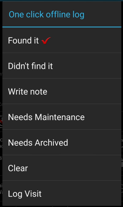
Just click on the desired log type and your offline log will be saved accordingly. The Clear option is only available if you already have an offline log stored for this cache. In this case the log type already stored is marked with a red tick in this menu.
You can also select Log Visit to open the normal logging screen to compose a complete log and store it.
Fieldnotes (a.k.a Drafts) are supported by geocaching.com and some opencaching sites and allow an offline logging of cache finds and batch uploading them to the website at a later point of time.
c:geo is supporting fieldnote export and also an automatic upload to the website (for geocaching.com).
The offline logged caches are marked by an orange line in your lists and with a red smiley on the map. To export the logs you have to open the relevant list of saved caches or the history and select Menu → Export → Field notes
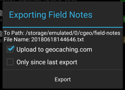
Fieldnote exports will be stored by c:geo in the directory /cgeo/field-notes in your internal storage with a date/time stamp used as filename as shown in the export dialog.
You can now either only export the fieldnote file to your device or additionally upload them to the geocaching website by enabling Upload to geocaching.com.
The option Only since last export will check the last upload date on geocaching.com and only export those field notes which are composed after this date.
After you exported your fieldnotes to the geocaching website, the website will show that you have pending fieldnotes on this page and you can compose your logs in your browser. Please be aware that it might take a minute after the upload until the website shows the pending fieldnotes.
This function can be activated in the settings for the cache coordinates and/or for its waypoints and will download Google maps images of the area around each saved cache both as street map and satellite view (a total of 5 images). It is a helpful feature if you plan to go caching without internet access (and maybe even without an offline map).
Also a basic street map will be shown at the bottom of the cache details page, the remaining maps are accessible by selecting Static Maps in the cache Navigation menu.
Please note, that there is a limit by Google of 1000 static maps per 24h per user(IP). Having a rather huge list of stored caches or even only some caches with many waypoints, you may easily reach this limit (as 5 images per cache and each cache waypoint are loaded). In this case some static maps might be missing.
The following shows an example of static maps for a cache. You can click the images to see a larger version:
| Description | Map |
|---|---|
| High zoom satellite view | 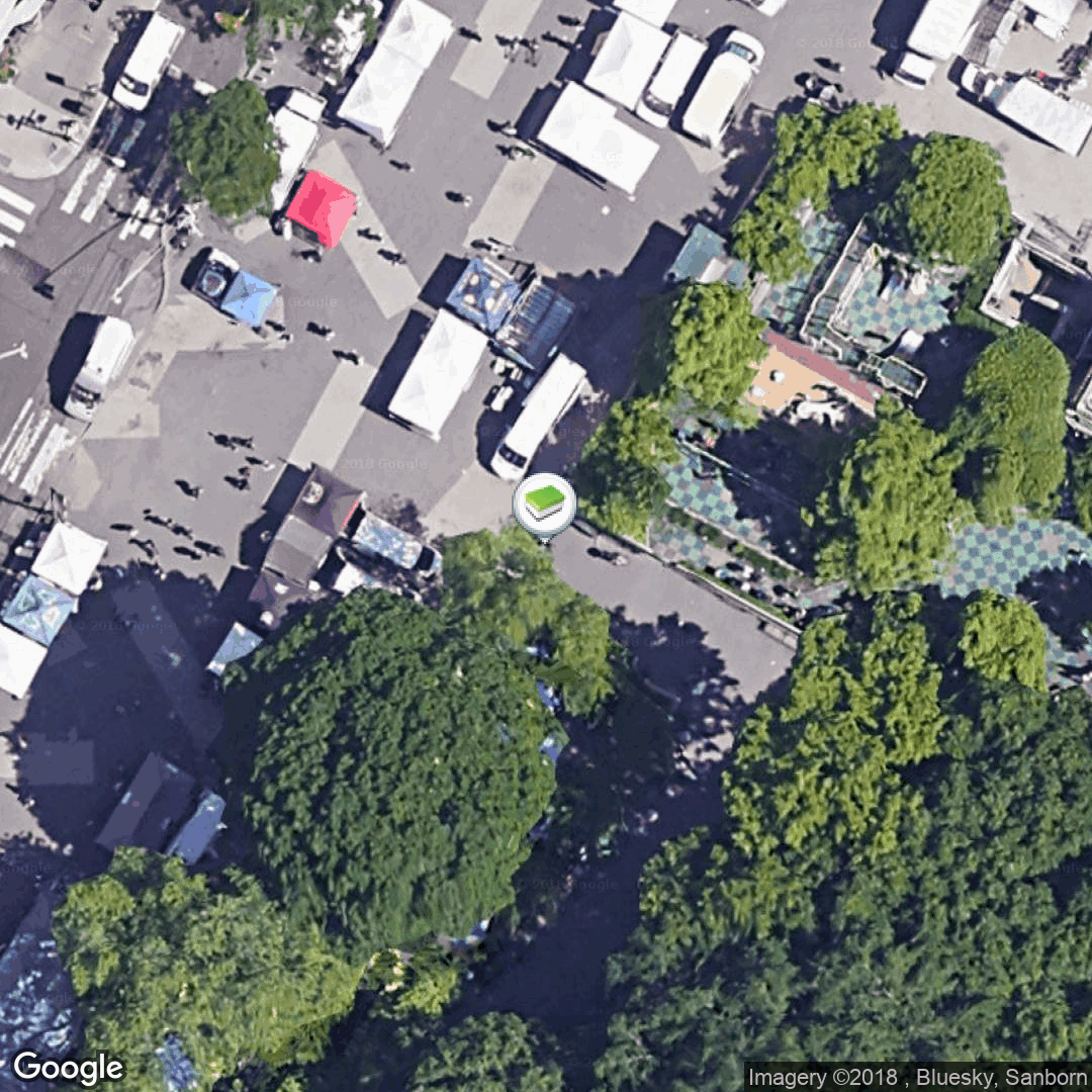 |
| Low zoom satellite view | 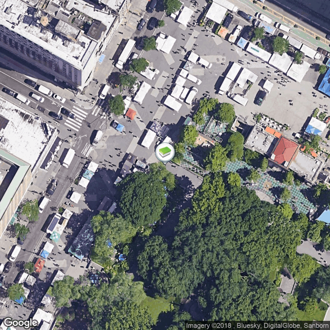 |
| High zoom street map view | 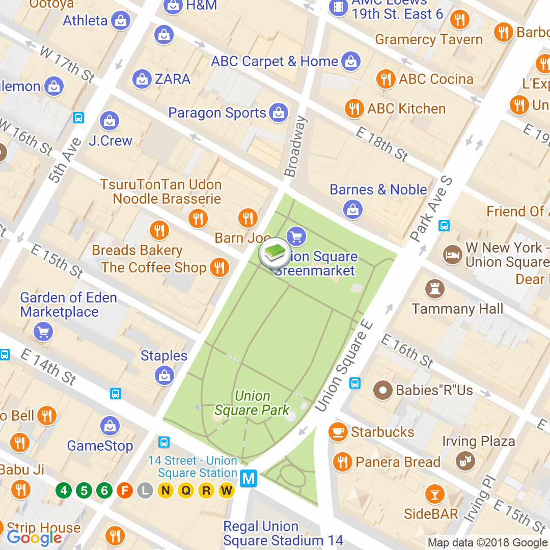 |
| Medium zoom street map view | 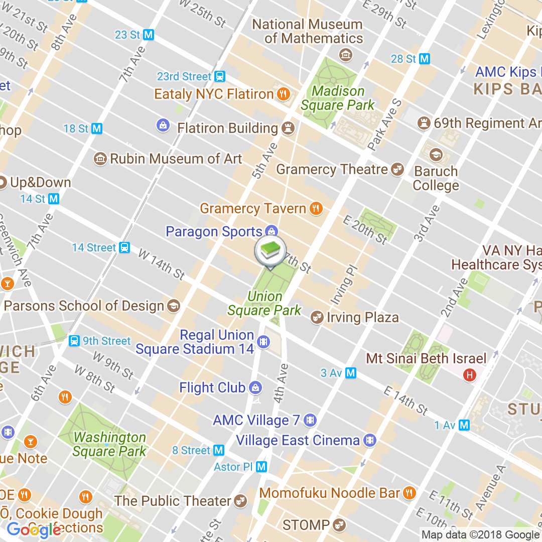 |
| Low zoom street view |  |
c:geo supports openstreetmap based offline map files using the mapsforge format.
Such files can be downloaded for your area/country from various sources, e.g. Mapsforge Download Server or OpenAndroMaps. With some effort you can also manually create your own openstreetmap based map.
Once you downloaded an offline map file, you have to store it to the directory on your device as defined in the settings. If the file is a valid mapsforge offline map, it will afterwards be shown in the map source selection on the live map or you can preselect the map file to be used in the settings.
